GeoTechnical Survey
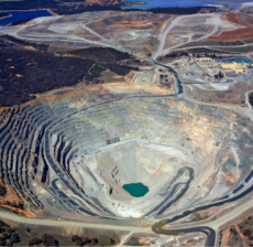
Geotechnical Survey is the process by which a geologist ventures into the field to observe, analyze, and record geological features directly from surface rock exposures, also known as outcrops. This method provides essential information about the composition, structure, and distribution of rocks across a specific area. Key elements of geological mapping include fault detection, dip and strike measurements, and strata identification, all of which help in understanding the earth's structural history and resource potential. Identifying fault lines and fractures is crucial for assessing seismic activity and land stability, while dip-strike measurements reveal the orientation of rock layers. Strata detection helps in understanding the sequence and age of sedimentary deposits. This data is vital for a variety of applications such as mineral exploration, groundwater assessment, civil engineering projects, and environmental management. Modern geological mapping often integrates GPS, GIS, remote sensing, and drone imagery to enhance accuracy and produce detailed digital geological maps. By interpreting the surface geology, geologists can infer subsurface conditions, making geological mapping a foundational tool in both scientific research and practical engineering.
Related Project
3D Laser Scanning is an advanced surveying technique that captures high-precision, three-dimensional data of…
Roof hen an unknown printer took a galley of type and scrambled itheiro make…
Roof hen an unknown printer took a galley of type and scrambled itheiro make…
Roof hen an unknown printer took a galley of type and scrambled itheiro make…
is a modern surveying method that uses drones equipped with high-precision GPS technology to…
Roof hen an unknown printer took a galley of type and scrambled itheiro make…


